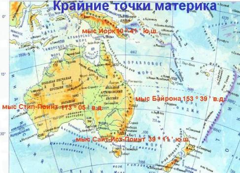
As you know, Australia is called not only the country, but the entire continent, which is located in the Southern Hemisphere and is washed by the waters of the Pacific and Indian oceans. Like any continent, Australia has its extreme points. If you recall the geography course in high school, the so-called most western, eastern, northern and southern points of the mainland, islands or countries are called. So, let's talk about all four extreme points of the mainland Australia.
The extreme northern point of Australia
Cape York is located in the very north of the Australian continent, which was discovered by the very latest. He was named James Cook in 1770 in honor of the Duke of York. This point is located on the peninsula of Cape York, which extends into the waters of the Coral and Arafuri seas and is famous for many underdeveloped territories. If we talk about the coordinates of the extreme northern point of Australia, then it is 10⁰ south latitude and 140⁰ east longitude. According to the administrative division of the Australian Union, Cape York refers to the territory of Queensland. And only 150 km from this southern point of the mainland is the island of New Guinea.
The extreme southern point of Australia
The southernmost point of the continent is South Point Point. It is on the north side of the Bass Strait, which is known to divide the mainland with the island of Tasmania. The cape itself is part of the Wilson-Promontory peninsula, and is also considered its southernmost point. As for the coordinates, South Point is located 39 ⁰ south latitude and 146 ⁰ east longitude. Administrative cape refers to the smallest state of Australia - Victoria. By the way, this most southern point is often visited by tourists, since this land area belongs to the oldest in Australia, the national park Wilson-Promontory.
The extreme western point of Australia
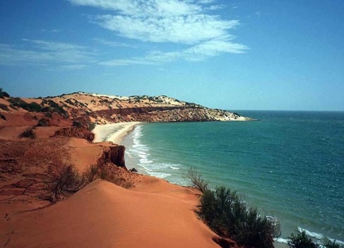
If we talk about the most extreme western point of Australia, then this is thought of Cape Steel Point. It is located on a small peninsula of Idel-Land and is washed by the waters of the Indian Ocean. Among the extreme points of Australia, this cape, towering at a level of 200 m, has the steepest bank of limestone origin. It is noteworthy that the first European who saw the cape in 1697, the Dutchman Willem Flaming named him "Steep Cape" in his native language (Steyle Hock). However, later, at the beginning of the XIX century, the French navigator Louis Freycinet renamed the protruding piece of land in the French manner. However, in 1822, Philip King returned the name "Steep Cape", but in English - Steep Point.
Geographically, the extreme western point of the continent is located at 26 ⁰ south latitude and 113 ⁰ east longitude. Regarding the administrative division of the Commonwealth of Australia, Cape Steepe Point belongs to the state of Western Australia Gaskoyne region. It is interesting that in our time this site of land is visited by many fishing enthusiasts.
The easternmost point of Australia
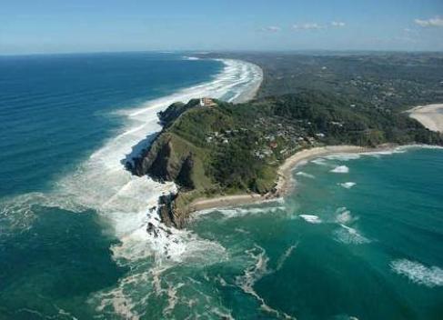
On the east coast of the Australian continent, Cape Byron, its easternmost point, rises. This picturesque land site, surrounded by the waters of the Indian Ocean, was named James Cook in 1770 in honor of the British Vice Admiral John Byron, who made a world tour around the 1860s. As for the geographical position, Cape Steepe Point is located at the intersection of 28⁰ south latitude and 153⁰ east longitude. According to the administrative division of the Australian Union, the easternmost point belongs to the state of New South Wales.
Now Cape Byron is the tourist center of Australia, where lovers of extreme sports are flocking. On the headland, surrounded by magnificent scenery and clean beaches, towers a beautiful white lighthouse - Byron Bay.